Current Temperature

CHICAGO WEATHER
Showing posts with label maps. Show all posts

Wednesday, November 1, 2023

Elected Chicago Board of Education district map

 The Illinois State Senate Democrat Caucus puts out new map for an elected Chicago School Board. This is the map below

You can also click here for an interactive map

Over at CapFax there is a demographic background. According to this tweet from Ben Szalinski the breakdown is 7 latino, 6 Black, and 5 white districts throughout the city. A vote in Springfield could come as soon as next week.

Sunday, May 29, 2022

Sun-Times: Ward map battle over, but bitterness lingers

As stated already Altgeld Gardens will soon be in Ward 10 it is especially noted in this Chicago Sun-Times May 16, 2022 article. Altgeld Gardens is currently in Ward 9

Wednesday, May 11, 2022

Sun-Times: Compromise on new City Council ward map could take issue away from Chicago voters

 The vote on this new map will take place when the City Council meets next week. You can check out what the ward remap looks like here.

From Sun-Times:

A deal has been struck on a new Chicago City Council ward map that, if approved, will keep the decision out of the hands of voters.

Under the deal, which still must be cemented by a City Council vote next week, the map will create 16 Black majority wards and 14 Latino majority wards, according to Ald. George Cardenas (12th).

Faced with a May 19 deadline to work it out themselves, the agreement calls for one fewer majority-Latino ward than the council’s Latino Caucus had wanted.

The proposed map also contains the city’s first ward with an Asian American majority.

Demographics are key to ward map negotiations. The city’s Black population is shrinking while the city’s Latino population is growing.

“There’s no need to bring the house down. We can own the house,” Cardenas said, referring to the next remap — in 10 years.

“Our day is coming for sure. We have to be patient and humble,” he said.

Cardenas offered a “kudos” to Mayor Lori Lightfoot for her work on Monday to facilitate the agreement and get all sides to sign on to the map.

Cardenas is grateful the map won’t go to a referendum — a step that, he said, would have siphoned energy from council members dealing with other pressing issues, including crime and a city casino.

Here's how our part of town looks in the new ward map. If you live in Altgeld Gardens, that development will now be in Ward 10.


Monday, December 6, 2021

Ward Remap 2021

 I wanted to share these maps with you to see the two proposals between the Chicago Coalition/Latino Caucus which is the map that Ald. Anthony Beale signed on to last week and then the Rules Committee/Black Caucus map that said Ald. Beale has an issue with.

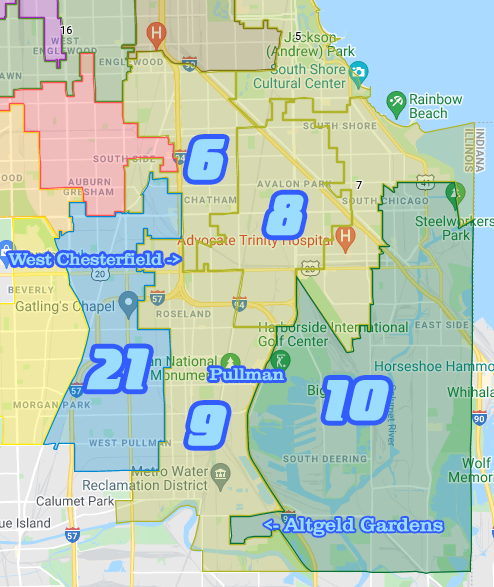
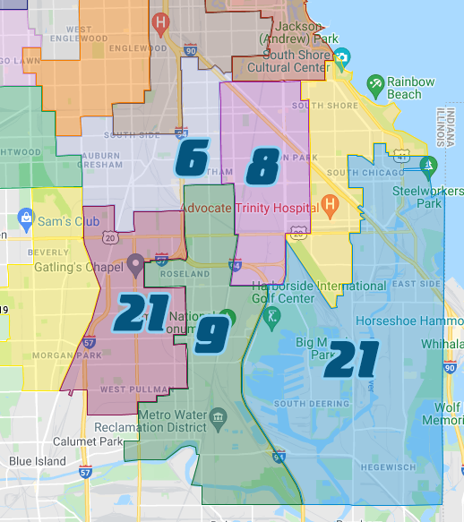
Let's start with the City Council Rules Committee Map. I pointed out some geographical points to show what's where. West Chesterfield which is bounded by State to about 93rd Street to King Drive to 95th Street will be split between Wards 6 & 8. It's safe to say currently that area is in Ward 9 solidly.

Altgeld Gardens is drawn into Ward 10. Pullman which is a special concern for Ald. Beale appears to remain within Ward 9. Also where's Ward 34 well from what I've seen so far it's being drawn up near downtown. They pulled a Ward 2 on us this time around, in the last remap in 2011 they drew that ward out of the South Loop and drew it further north. As you see Ward 21 goes further south where 34 used to be and Ward 9 takes a little territory from 34 as well.

As for the Chicago Coalition map which is what Ald. Beale signed on with, especially as far as getting it up for a potential referendum next year. The only changes from the 2011 map is that Ward 6 is sent further west taking from 21 the Chatham Market mall and Simeon High School. Ward 21 again takes up most of what used to be Ward 34 and going further south. Ward 9 looks basically the same with Pullman and Altgeld Gardens with the boundaries and the ward goes all the way up to 87th Street between State and Cottage Grove.

We got basically two very different maps for this part of the south side. Perhaps some of you have your thoughts on these maps. Feel free to email us your thoughts it's in the sidebar.

Tuesday, January 30, 2018

Route of future Red Line extension has been determined

[VIDEO] The long awaited extension continues to move forward with a specific routing south to 130th Street on the far south side of Chicago. Of course there's still a process through getting the financing from the federal and state governments for construction on this new L line can start. When the process ends we're looking towards sometime next decade before the building starts.

Here's a basic map of the future extension via Tribune Graphics
  Also the question is already being asked about how to get the money to build this new L line 
Finally here's the CTA page for the Red Line extension.

Thursday, March 17, 2016

Whole Foods Market distribution facility coming to Pullman

The map above were you see that red marker, a Whole Foods Market distribution center is expected to be built there.
Whole Foods plans to build a distribution facility in the Pullman neighborhood on the South Side that would employ 150 people.

The 140,000-square-foot facility will be at 720 E. 111th St., according to the city of Chicago. The site is currently vacant.

The center, to open in early 2018, will replace an existing Munster, Ind., facility and will serve up to 70 Whole Foods stores in the Midwest and Canada, according to the city.

The city "will consider approximately $7.4 million in tax-increment financing assistance" for the project, according to a statement. The subsidy is being considered "to ensure the site was competitive with the existing facility in Indiana," the statement said.

The Whole Foods distribution center will be built on a 17-acre site owned by a venture of Chicago Neighborhood Initiatives, a unit of Minneapolis-based U.S. Bank, CNI President David Doig said in an email. Doig's real estate company will prepare the site for an industrial developer, which will build the distribution center and then lease it to Whole Foods.

The facility will be able to handle cold and dry storage and will have office space, CNI said.
More on the future site of the facility and adjacent properties:
The former Ryerson property also includes a Method soap factory that opened about a year ago and includes a Gotham Greens farm on its roof.

Doig's CNI also developed a new shopping center on the site anchored by a Wal-Mart big box store, and more retailers plan to open stores there. The neighborhood also received a boost about a year ago, when President Barack Obama designated the area a national monument, citing its manufacturing and labor history.

You may have seen this vid below on CBS 2 this morning, BTW

Tuesday, March 8, 2016

#MBMHMC I don’t live in Chi-Raq, but that doesn’t mean it doesn’t exist

This report is via My Block My Hood My City by their head of data, Matthew Pietrus. The map above chronicles homicide hotspots throughout Chicago:
After analyzing homicides locations in conjunction with demographic data, I found that of these thousands of homicides from 2010-2015, two thirds of them occurred in neighborhoods that are two thirds or more black. Compared to just over 12% in predominantly Hispanic neighborhoods and under 2% in predominantly white neighborhoods, it is clear that violence is not equally shared.

Unfortunately, this is not news. Most Chicagoans understand the disparities that exist in the city so studies like these can seem repetitive. But the significance of this map, and other studies like it, lies not in the data displayed on its surface but in the social interactions that create it. While what is occurring is certainly of importance, only in understanding why something is occurring can change happen.

That is why the story this map tells, the story of Chi-Raq, is an important one.

With the mention of that term, many readers may have moved on from this piece, and with understandable frustration. With massive clusters of homicides isolated in the South and West sides of the city, to many Chicagoans, Chi-Raq, the city more deadly than a warzone, is not the city they know nor is it the reality they face. For this reason, there has been constant backlash to the city’s new name, dating from the term’s inception to Spike Lee’s recent film. However, is this image of Chicago really a misrepresentation? More importantly, is our outcry over the term Chi-Raq really more important than the larger socioeconomic, racial, and violent disparities that it brings up?
Conclusion:
Similarly, for city officials and community members to continue a blasé approach towards reading these stories is a form of complicity, permitting the city to continue its violent polarization. Instead of becoming numb to statistics and these stories, we instead need to mobilize when Chicagoans like Bettie Smith, Quintonio LeGrier, and Tyshawn Lee are killed. We need to call our aldermen, protest, and make our dissention known.

In the end, this map tells the story of Chicago’s segregation. This story is not just one depicting a lack of cultural integration but one telling of a social isolation which disproportionately impacts black communities. But just because this may not be the story of your Chicago does not mean it is a story you should ignore.
Now how do we change this idea of violent polarization in those violent communities?